

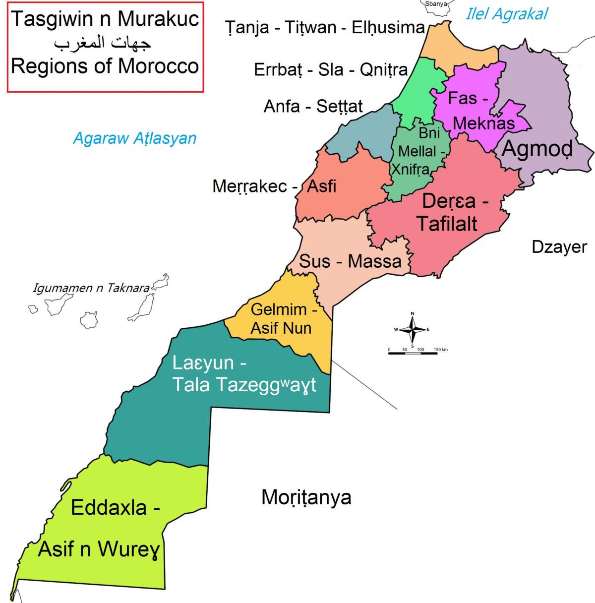
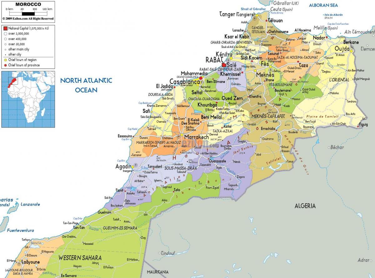
You can find on this page the Morocco region map to print and to download in PDF. The Morocco political map presents states, regions, provinces and surrounding areas of Morocco in Africa.
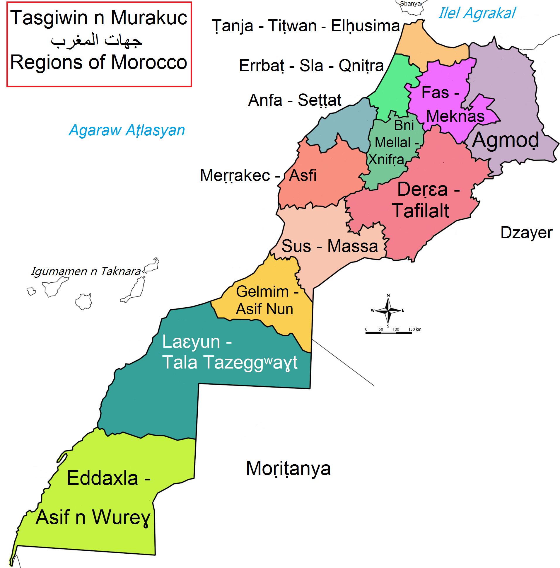
The Morocco regions map shows surrounding areas and provinces of Morocco. This administrative map of Morocco will allow you to know regions of Morocco in Africa. The Morocco regions map is downloadable in PDF, printable and free.
As part of a 1997 decentralization/regionalization law passed by the legislature, sixteen new regions were created. These regions as its mentioned in Morocco regions map are: Oued Ed-Dahab-Lagouira, Laâyoune-Boujdour-Sakia El Hamra, Guelmim-Es Semara, Souss-Massa-Drâa, Gharb-Chrarda-Béni Hssen, Chaouia-Ouardigha, Marrakech-Tensift-El Haouz, Oriental, Grand Casablanca, Rabat-Salé-Zemmour-Zaer, Doukkala-Abda, Tadla-Azilal, Meknès-Tafilalet, Fès-Boulemane, Taza-Al, Hoceima-Taounate, Tangier-Tétouan.
Morocco is divided into sixteen regions, which in turn are subdivided into sixty-two provinces and prefectures as you can see in Morocco regions map. Each of these regions has geographical and historical features which make it interesting. A Moroccan region is governed by a Wali, nominated by the King. The Wali is also governor of the province (or prefecture) where he resides.
Before 1997, Morocco was divided into 7 regions as its mentioned in Morocco regions map: Central, Eastern, North-Central, Northwestern, South-Central, Southern, Tansift. As part of a 1997 decentralization/regionalization law passed by the legislature 16 new regions (provided below) were created. It is the current highest administrative division of Morocco.

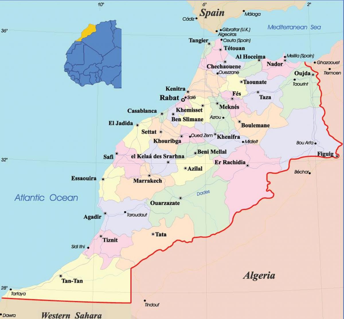
The Morocco political map shows regions and provinces of Morocco. This administrative map of Morocco will allow you to show regions, administrative borders and cities of Morocco in Africa. The Morocco political map is downloadable in PDF, printable and free.
Morocco is a de jure constitutional parliamentary monarchy with an elected parliament as its shown in Morocco political map. With the 2011 constitutional reforms, the King of Morocco still retains few executive powers whereas those of the prime minister have been enlarged. Opposition political parties are legal. Politics of Morocco take place in a framework of a parliamentary constitutional monarchy, whereby the Prime Minister of Morocco is the head of government, and of a multi-party system. Executive power is exercised by the government. Legislative power is vested in both the government and the two chambers of parliament, the Assembly of Representatives of Morocco and the Assembly of Councillors. The Moroccan Constitution provides for a monarchy with a Parliament and an independent judiciary.
The constitution grants the king honorific powers; he is both the secular political leader and the "Commander of the Faithful" as a direct descendant of the Prophet Mohammed (see Morocco political map). He presides over the Council of Ministers of Morocco; appoints the Prime Minister from the political party that has won the most seats in the parliamentary elections, and on recommendations from the latter, appoints the members of the government.
Following the March 1998 elections, a coalition government headed by opposition socialist leader Abderrahmane Youssoufi and composed largely of ministers drawn from opposition parties, was formed. Prime Minister Youssoufi government is the first ever government drawn primarily from opposition parties in Morocco, and also represents the first opportunity for a coalition of socialists, left-of-center, and nationalist parties to be included in the government until October 2002. It was also the first time in the modern political history of the Arab world that the opposition assumed power following an election. The current government is headed by Abbas El Fassi as you can see in Morocco political map.
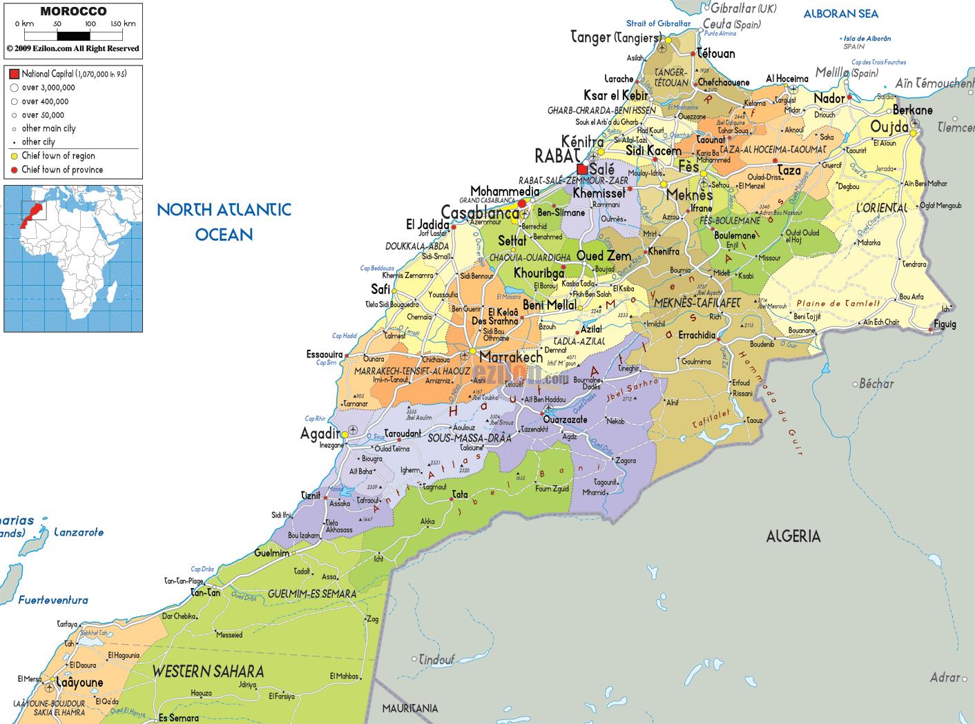
The Morocco states map shows all departments and regions of Morocco. States map of Morocco will allow you to know areas and cities of Morocco in Morocco. The Morocco states map is downloadable in PDF, printable and free.
In Morocco, the 61 second-level administrative subdivisions are 13 prefectures and 48 states as its mentioned in Morocco states map. They are subdivisions of the 16 regions of Morocco. Each prefecture and state are subdivided into districts (cercles, sing. cercle), municipalities (communes, sing. commune) or urban municipalities (communes urbaines, sing. commune urbaine), and arrondissements in some metropolitan areas. The districts are subdivided into rural municipalities (communes rurales, sing. commune rural).
Morocco is divided into 37 states and 2 wilayas as you can see in Morocco states map: Agadir, Al Hoceima, Azilal, Beni Mellal, Ben Slimane, Boulemane, Casablanca*, Chaouen, El Jadida, El Kelaa des Sraghna, Er Rachidia, Essaouira, Fes, Figuig, Guelmim, Ifrane, Kenitra, Khemisset, Rommani, Khenifra, Khouribga, Laayoune, Larache, Marrakech, Meknes, Nador, Ouarzazate, Oujda, Rabat-Sale*, Safi, Settat, Sidi Kacem, Tangier, Tan-Tan, Taounate, Taroudannt, Tata, Taza, Tetouan, Tiznit; three additional states of Ad Dakhla (Oued Eddahab), Boujdour, and Es Smara as well as parts of Tan-Tan and Laayoune fall within Moroccan-claimed Western Sahara.
From independence to 1997, Morocco was divided into states and prefectures as its shown in Morocco states map. They are supposed to be at the same administrative level. However, the prefectures are much smaller in area, as each one contains only one or two cities and their suburbs. Many sources do not even list the prefectures. The numbers of states and prefectures have grown fairly steadily over the years.